
A new way of quantifying and monitoring Urban Forest dynamics
Nowadays, remote sensing is one of the most important technologies for forest inventories. The availability of open data from Copernicus constellation and national programs of aerial photogrammetry capture and LiDAR (Light Detection and Ranging) has allowed the development of new urban forest inventory techniques. The combination of this new data sources with machine learning techniques, open software and computing capability is the basis of a revolution in terms of forest inventory.
LiDAR area-based approach technology is operationally implemented for forest inventories where this kind of data are available (e.g. Spain). In recent years, this technology has been used mostly in rural areas. Nevertheless, it could be a perfect solution for several Urban Forestry cases. One of its main limitations is the cost of data acquisition, which involves long periodicities between acquisition campaigns. Data obsolescence due to natural or anthropogenic disturbances constrains its applicability, especially in dynamic ecosystems.
However, other data sources are available to complete LiDAR data such as Sentinel2 – a satellite of the Copernicus constellation – or digital aerial photogrammetry, whom programs are much more widespread at national level and have shorter periodicities. For this reason, their use for forest inventory could have great potential for monitoring forest with temporal continuity.
In the present article, we show the potential of the combination of different data sources in forest inventory in a concrete case study.
The case study
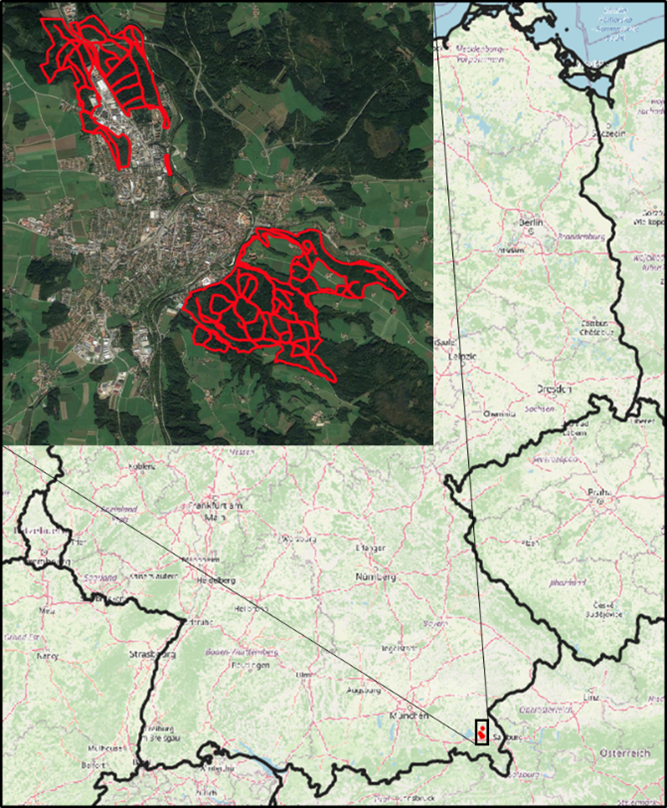
The study area comprises the urban forest of the municipality of Traunstein, located in Upper Bavaria (Germany), between Munich and Salzburg. This pilot project has been the first inventory carried out with model transfer from LiDAR massing methods to photogrammetric data of the state of Bavaria. The objective of this study was twofold: to evaluate the accuracy of this methodology in the predictions of the most important metrics that should be included in every forest inventory (such as dominant height, quadratic mean diameter, basal area and volume), and to analyse the potential of this technology in urban forest inventory.
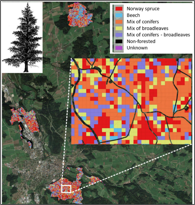
Satellite data has been used in order to classify forest species. We generated a forest species mapping for the whole study area as a basis for the application of the fitted models. The assessment of the classification accuracy ranged from 76.1% for pure Norway spruce stands (due to confusion with other conifers) to 89.2% for pure beech stands.
Once we identified the species in every pixel of 20x20m, we fitted the model for the forest variables selecting some LiDAR statistic transferrable between LiDAR and photogrammetric point clouds thanks to the experience our R&D team. To do so, we combined field data from 2008 (98 inventory plots) with a LiDAR flight using machine learning techniques. We transferred these algorithms to a photogrammetric point cloud captured in 2020. The assessment of the goodness-of-fit of the models was carried out with an independent sample of 38 plots surveyed in 2021, calculating the mean quadratic error in absolute (RMSE) and relative (rRMSE) values.
This shows the potential of combining different data sources in forest inventories based on remote sensors for urban forests. The necessary stratification can be generated with a suitable resolution by means of classification of Sentinel-2 satellite images and ground truth data obtained in the field. The incorporation of this type of images in forest inventories over large areas, especially in inventories based on LiDAR technology, can lead to an improvement in the resolution of forest species mapping and ultimately to an improvement in the estimation of forest inventory variables, especially in mixed stands. Regarding urban forest inventory metrics, the model fitting results on the LiDAR point cloud were satisfactory, with a mean quadratic error below 14 % for all analysed variables.
The existence of national aerial orthophotography capture programmes with periodicities between 1, as in Bavaria, and 3 years, as in Spain, is common in Europe. Therefore, these results have a huge potential impact in those countries where there is at least LiDAR coverage, which allows normalising the heights of photogrammetric point clouds, for their application in forest inventories.
The development of specific photogrammetric models and their transfer to LiDAR models and vice versa can provide an opportunity to take advantage of already captured field data, which is one of the most important costs of LiDAR inventories, thus maximising data utilisation when addressing future forest inventories once new LiDAR or photogrammetric coverages become available.
Authors:
Jorge Olivar1, José Luis Tomé1, Santiago Martín1 and Astor Toraño2
(1) Agresta S. Coop
(2) Chair of Forest Growth and Yield Science, Technical University of Munich